Having good health is the cornerstone of living an active and satisfying life. Many things influence our well-being, such as our genes, food, way of life, age, and ability to get medical treatment when needed. However, there are also more global factors that we may overlook on a daily basis, but they influence our lives, even if not directly, but very severely. And what is the best way to follow such things? Of course, from above! Earth observation (EO) satellite cameras can shed light on the crucial environmental factors, such as:
Air Pollution
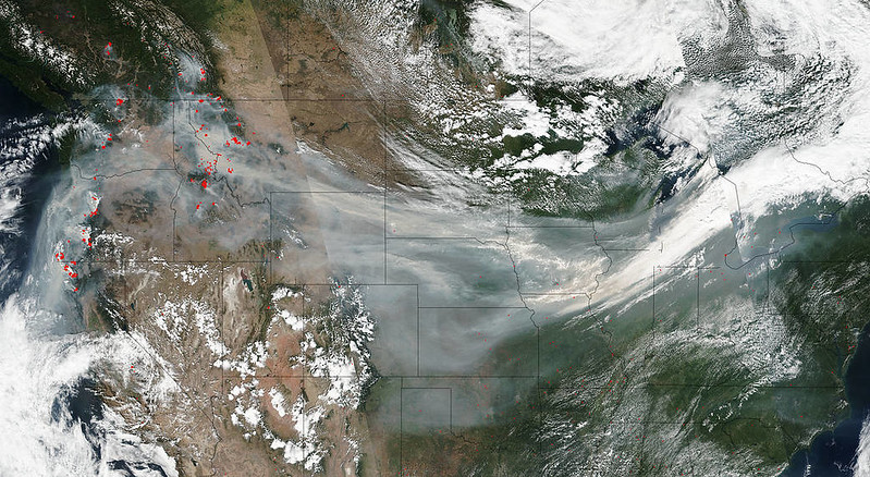
When it comes to global health threats, air pollution is the first that comes to mind. According to the World Health Organization, 9 of 10 people worldwide breathe low-quality air. Power plants, factories, home heating and cooking systems, farms, wildfires, and vehicles contribute to this air pollution. The likelihood of exposure is higher in urban areas due to the concentration of pollutants and the lack of flora in neighboring areas.
Satellite cameras used for people’s health have greatly aided environmentalists in tracking the sources and spread of pollution on a global scale. Plus, they help study and monitor air quality 24/7. Measurements of air contamination and its global movement, as well as the effectiveness of anti-pollution measures like automobile emission reduction regulations, are all possible thanks to the data collected by satellites. Wildfires and human activity can be better understood with the use of these statistics.
Ozone Depletion and UV Radiation
Solar radiation may cause serious damage to our planet, but the ozone layer in the upper atmosphere shields us from it. After being discovered a few decades ago, the gradual reduction of the ozone layer has emerged as a major concern on a worldwide scale, with human activities serving as the main cause.
As stated by the UN Ozone Secretariat, UV radiation caused by ozone depletion may result in the following health threats:
- vision problems, such as cataracts, eye cancer, or even partial or complete loss of vision;
- lowered immunity and an increase in autoimmune and viral illnesses;
- sunburns, photoaging, and various skin problems, up to skin cancer.
To better track changes in ozone-depleting chemicals and, by extension, UV radiation, satellites analyze a variety of atmospheric trace substances, particularly ozone and ozone-depleting compounds.
Mosquito- and tick-borne diseases
Apart from being annoying bugs that can ruin your picnic, these insects can be carriers of extremely dangerous and even lethal diseases, like malaria, Lyme disease, West Nile virus, etc.
Even though satellites can’t detect ticks and mosquitoes from orbit, they can assist in detecting and tracking their potential hotspots. These creatures have very precise microclimate, soil, and feeding needs to live and breed. If you have satellite data, you can recognize exactly where those circumstances are most likely to be met and, hence, where you may find ticks and mosquitoes. Public health organizations and local governments utilize satellite-based information to alert the public about risk regions.
How can satellite remote sensing be useful to humans, and how does it impact our lives?
Apart from these implementations, the uses of satellite imagery for improving people’s lives are countless in the areas you didn’t even think about. Here are just some of them.
Fly Safety
Scientists can keep an eye on the potentially dangerous volcanic ash and particles that airplanes encounter using satellite remote-sensing. Before takeoff, pilots may make better judgments based on more accurate and up-to-date information about potential dangers along their flight route.
Wildfires
Knowing the exact location and starting point of wildfires is vital information for the general community. They may happen even in cold and humid regions like Canada, Norway, and Alaska, which makes them a worldwide problem.
Weather Forecasts
No matter how you receive your weather reports—on TV or through a mobile app—most likely, satellites are involved. However, weather forecasters frequently use images created from data collected by satellite cameras.
Urbanization Monitoring
Research on the effects of urbanization on the environment and strategies to mitigate such effects is crucial. Experts predict that around 70% of the global population will reside in urban areas by 2050. Evolving landscapes may be tracked much more easily with the use of remote sensing technologies.
Final Words
The importance of satellite images for people is hard to overestimate. Remote data collection is an effective tool for comprehending and addressing pressing environmental and social issues. However, due to the scarcity and difficulty in acquiring remote sensing data, it was difficult to gather the necessary knowledge for a long time. The availability of new information sources, improvements in processing speed, and solutions that distribute data to important decision-makers have made the widespread use of satellite cameras` data a great option. We may not see them, but they see everything and take care of us on multiple levels of our lives.
Last Updated: January 24, 2024


